| Title: | Not-Nasty Rock | | Area: | Opal Creek Wilderness | | Elevation: | 4618 Feet | | Elevation_Gain: | 2658 | | Trail: | Nasty Rock Trail | | Links: | Nasty Rock Trail | | Difficulty: | day hike | | Notes: | For many years hikers have taken the Nasty Rock Trail north to this prominent rocky point we assumed to be Nasty Rock, it is in fact not Nasty Rock. The real Nasty Rock is one mile further north. With no name on the map for this rocky point, I am now refering to it as Not-Nasty Rock. | | Trail_Number: | 3356 | | Route: | From Salem, take Hyw 22 east 23 miles to Little North Fork Road. Take this road 17 miles, remain left at the junction to Shady Cove. Continue on 2209 past Tin Cup Creek to a campsite area on the rightside of the road. Park here and cross the road to begin your hike. | | TH_elevation: | 1960 | | Distance: | 2.5 | | USGS_15: | Mill City | | USGS_75: | Rooster Rock | | Reference: | Oregons Hidden Wilderness | 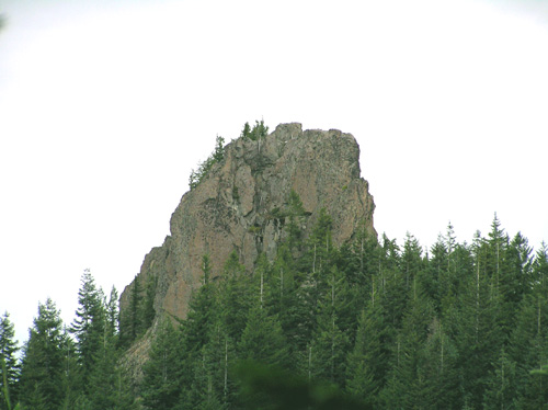
Not-Nasty Rock - - - November 14, 2004 | | Type: | Peak | | Experienced_Only: | yes | | Day_Hike: | yes |
|
|