| Title: | Hawk Mountain |
| Area: | Mt Hood National Forest |
| Elevation: | 5277 Feet |
| Elevation_Gain: | 727 |
| Trail: | Rho Ridge & Hawk Mountain |
| Misc: | Hawk Mountain served as a forest fire lookout site from 1917 to 1967. It had a unique 60-foot three-legged platform for fire spotting, and in 1936 this cabin was built for housing. |
| Links: | Hawk Mountain Lookout, Trip Journals - 8/27/04, 8/28/04, 8/16/05, 9/3/05, 9/18/05 |
| Notes: | To get to Hawk Mountain on this suggested route, travel first on the Rho Ridge Trail #564 about two miles, before turning up the hill on unmarked #564A, the Hawk Mt Trail. Rho Ridge Trail is an ULT, meaning Urban Link Trail. Expect evidence of motorbike and quad travel. |
| Trail_Number: | 564 & 564A |
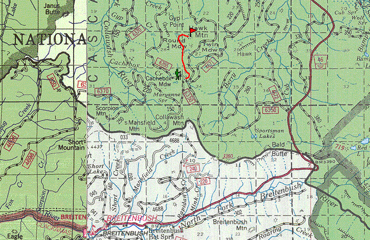
| Route: | From Detroit, take the Breitenbush Road #46, traveling just over 17 miles to Rd #6350, turn left, and in about 5 miles turnleft again at #6355 at a four way junction towards Cachebox Meadows. In two tenths of a mile at the junction with #150 look to the right for the trailhead. |
| TH_Access: | June 7 |
| TH_elevation: | 4550 |
| Alt_trail: | Rho Ridge Trail from Graham Pass, 5.8 miles |
| Distance: | 2.3 |
| USGS_15: | Breitenbush Hot Springs |
| USGS_75: | Breitenbush Hot Springs |
| Reference: | 100 Hikes in Northwest Oregon by Sullivan / Fire Lookouts of Oregon & Washington by Kresek |
U.S.Forest Service |

Hawk Mountain - September 18, 2005 |
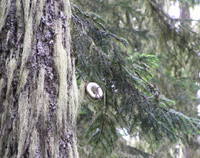
abandoned telephone insulators are still on some trail-side trees |

look for these yellow diamonds that mark this Urban Link Trail |
| Type: | Peak |
| Day_Hike: | yes |
| Historic: | yes |
| Scenic: | yes |